It is our goal to provide you with the resources and information necessary to being preparing for your journey along the Annapurna Circuit. Bellow, please find articles relating to all the details of your trip. If you have any questions feel free to email us at grabthebackpacks@gmail.com.

The view from the stupa in Ghyaru
Trail Notes
Gallery
(More information and related links are available near the end of this article)
What is the Annapurna Circuit?
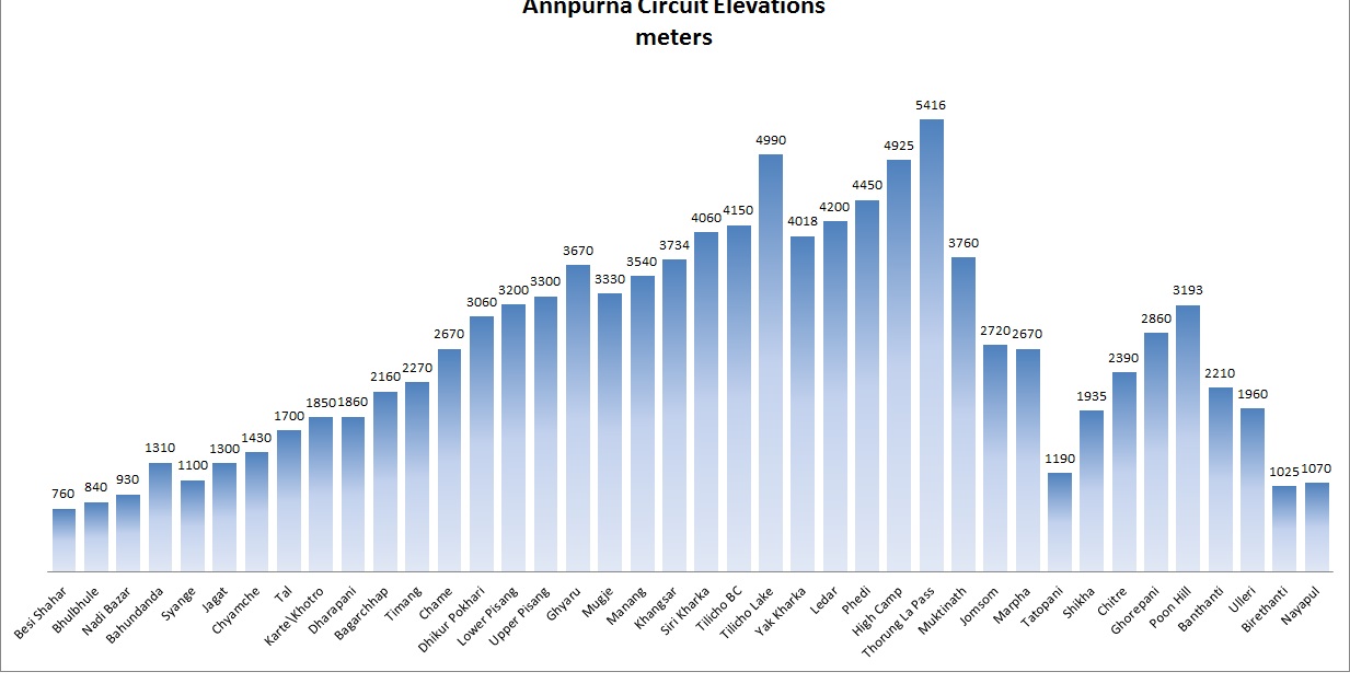
The Annapurna Circuit winds through the Marshyangdi river valley, across the Throng La Pass, and descends into the Kali Gandaki Gorge. Taking you through the four regions of Lamjung, Manang, Mustang and Myagdi, Nepal. It is a trail that offers majestic views of the Annapurna I, II, III, and IV, East Chulu, West Chulu, Grangapurna, and Machhapuchhre peaks as you hike through the Himalayan mountain range. Waterfalls cascade down cliff slides as you hike along the Marsyangdi Nadi (river), butterflies and leeches dance in the warm jungles of the lower altitudes, the world’s highest lake – Tilicho Lake (4,949 m) is reachable from a side trail, and all the while Nepali’s work their fields as caravans of yaks and donkey’s continuously go up and down the trail.
Traditionally a 15 to 21 day, 135 mile (215 km), is usually trekked in a counterclockwise direction, starting from Besishar and ending in Naya Pul. This direction is extremely helpful with acclimatization, as the heights jump drastically upwards clockwise from Marpha through the Throng La Pass. The complete trek will end in Pokhara, with the last leg nearly always completed by taxi or bus.
The construction of roads, especially on the eastern side from Jomosom to Beni, is making the journey by foot more unpleasant. If road development continues as planned, the trail could be reduced to as little as 19 miles (30 km). Alternative routes are being developed so that you do not need to walk along the same road as the buses and jeeps. Always check with a local ACAP for the current conditions of these routes (sometime seasonal suspension bridges are required, some areas are prone to landslides, etc.).
More information regarding:
- Trail Notes (written Fall 2013)
Trail Notes (2013) PDF: no images, for easy printing
Annapurna Curcuit Elevations - Itinerary: Planning Your Days
- ACAP and TIMS Permits
- Budgeting – How much does it really cost? (coming soon)
- Packing the Backpack: your easy, no fault, gear list
- Safe Drinking Water Stations (coming soon)
- Transportation along the trail (coming soon)
- Food Along the Trail
- Photo Gallery – Fall 2013, Sara & Tzachi
- Choosing the Trail For You: Still debating between the two most acclaimed hikes in Nepal, the Annapurna Circuit and Everest Base Camp Trail? Well, here is a comparative of the pros and cons of each trail.
