Your trail notes and guide to hiking the Annapurna Circuit!
More Information on the Annapurna Curcuit click here!
Annapurna Curcuit Elevations
Annapurna Circuit Trail Notes -PDF
(all the information bellow, but without images for easy printing)
Notes about the Trail:
The hike is most commonly trekked counter clockwise from Besi Shahar to Beni or Naya Pul (a popular alternative trail that offers a well-known viewpoint from Poonhill) because of the steady elevation increase between the villages within the Marshyangdi river valley as you progress towards the Throng La Pass.
The village names have many spellings depending on what map or guidebook you are reading. Use your power of deduction and reasoning to stay alert. We will do our best to provide the common and alternative names when applicable. Not all villages are clumps of buildings, but rather sprawling settlements. Be aware that many times the same village can exist on both sides of the river.
Just like the village names, the stated altitudes of places will vary depending on the source. Most importantly, remember to listen to your body! Drink plenty of water!!! Pushing through headaches is not a good idea. Vomiting is a sure sign of altitude symptoms and should be taken seriously; descend immediately until the symptoms stop, followed by a day or two of acclimatization.
Abbreviations used within the trail notes:
-
SWDS: Safe Water Drinking Station
-
km: kilometer
-
ft.: feet
-
hr. and min.: hours and minutes
Besi Shahar to Bhulbhule
Besi Shahar to Khundi: 1 hr. 30 min. – 1 hr. 50 min.
The Annapurna Circuit trail exits straight out of the town of Besi Shahar (760 m, 2493 ft.). Just follow the main road north and you will be on the trail. Note that this road is also the highway and therefore has jeeps and buses that travel along it. To avoid dust being blown up in your face, many trekkers opt to take the one hour local bus to Bhulbhule, or hire a jeep (note that a jeep will not leave without 9 – 12 people) as far as Syange. Taking a mode of transportation is a good option if you are pressured for time, as you can make quick progress along the trail at these lower altitudes that you will not be able to make once the elevation increases.
The trail from Besi Shahar continues straight, along the western (left) side of the Marshyangdi Nadi (river) to Khudi.
Khudi to Bhulbhule: 30 min.
Within Khudi cross the large, metal, vehicle bridge and continue along the trail, staying on the western side of the river. In slightly over 2 km, you will come to the village of Bhulbhule (840 m, 2576 ft.). Within the village cross another pedestrian bridge that will bring you to the eastern (right) side of the river.
(Alternative trail: It is possible to cross an older, pedestrian bridge to the eastern side of the river within Khudi. Continuing through the older section of Khudi village to Bhulbhule, along the eastern side of the river.)
Bhulbhule to Jagat
Bhulbhule to Bahundanda: 3 hrs.
From Bhulbhule, you will follow the trail marked towards Manang, most of which runs parallel to the river — offering staggering views of dramatic waterfalls from the surrounding valley walls and the constant melody of rushing water. Continue along the wide dirt road to Nadi Bazar (930 m, 3051 ft.). From Nadi Bazar to Bahundanda (1310 m, 4298 ft.), you will cross two bridges but remain on the eastern (right) side of the river. You will ascend into the village of Bahundanda, where there is an ACAP and TIMS checkpoint, along with many teahouses.
Bahundanda to Jagat: 3 hrs.
Continue out of Bahundanda, staying on the eastern side of the river. The trail has a slight descent and allows for good time.
The ascent from Syange (1100 m, 3609 ft.) to Jagat (1300 m, 4265 ft.) begins after you cross the bridge to the western (right) side of the river. For most of the way you follow the car road, though there is one porter’s short-cut section that allows you to hike up the cliff side (really, it is not that bad) instead of walking the car road’s snake path. From the top of the hill, it is just a few meters descent into Jagat.
Jagat to Darphani
Jagat to Chyamche (Chamje): 1 hr.
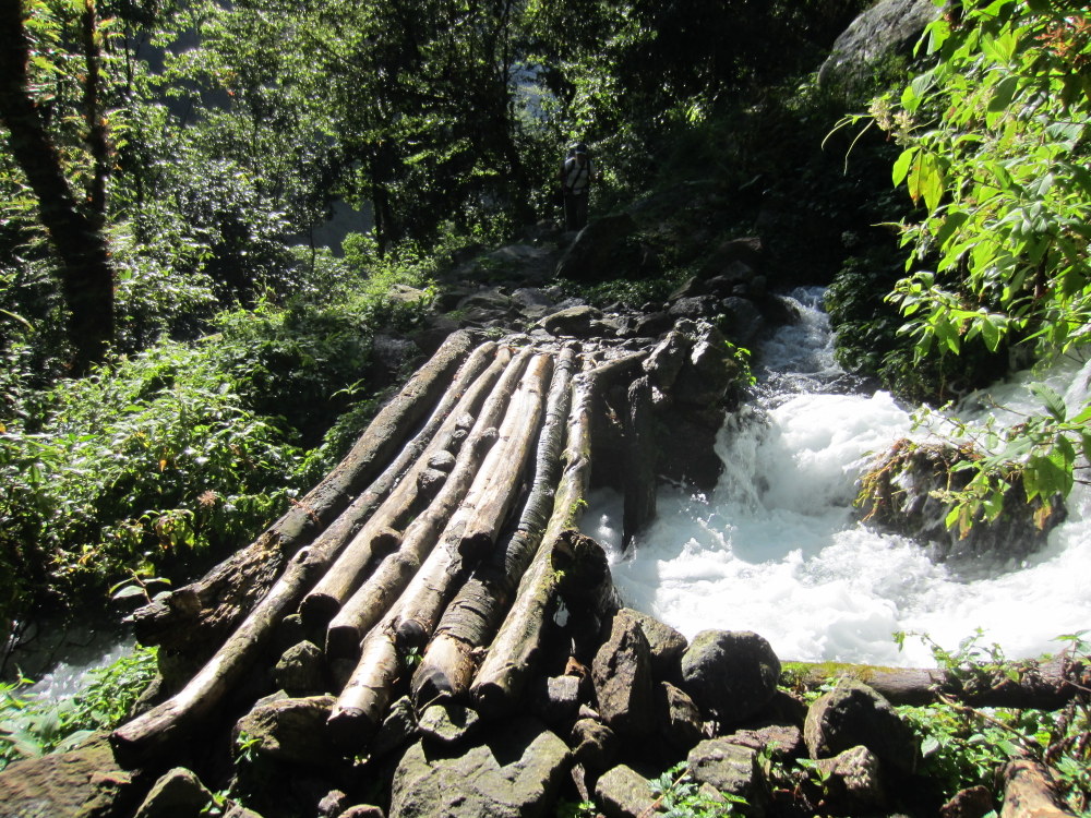
Continue through town, exiting by the main road. 20 minutes or less, after the village of Jagat, the old trail continues up the hillside to the left. The trail leads to Chyamche (1430 m, 4692 ft.), a small village nestled into the mountain, overlooking the river. Climbing up the hillside you are transplanted to the middle of the jungle, with jumping worms, crossing swift flowing waterfalls on log bridges, and lush green ferns. (Do not take this route if it is raining or still wet, as the trail can be overflowed by the streams. Rather, stay along the main road till Chyamche.)

Trail Split after Jagat
Trail to Chyamche
Chyamche to Tal: 1 hrs. 45 min. – 2 hrs.
After Chyamche, you cross a bridge to the eastern side of the river and begin the ascent to Tal (1700 m, 5577 ft.). The climb will last around 1.5 hours, with a mixture of stairs and dirt roads waving and snaking along the hillsides. After reaching the top, the trail will meander on flat ground until you reach the entrance way to the Manang District. From there, it is a short climb down to the river, and a flat walk into the village of Tal.
In Tal there is a SDWS located on the right hand of the street towards the end of town.
Tal to Dharapani: 2 hrs.
From Tal onwards, when in doubt, follow the the signs for Manang.
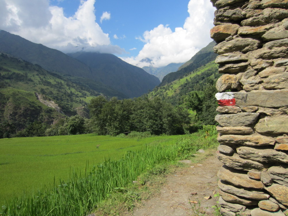
Red/White “trail markers” for the Annapurna Circuit
2 km after Tal, you will cross a bridge to western (left) side of the river. Right before entering Karte\Khotro (1850 m, 6069 ft.), you will cross back to the eastern (left) side of the river. The trail is relatively flat, 1 hour and 15 minutes.
(Relatively Flat Trails: In Nepal, this means that the up and downs average out. Lesson number one, it is all relative in Nepal. And when you have the worlds’ highest mountains as your measurement, “flat” and “steep” become a-typical.)
After leaving Karte, cross a bridge to the western (left) side of the river. Continue along the ridge to the village of Dharapani (1860 m, 6102 ft.) — 45 minutes later.
Darphani to Chame
Dharapani to Timang: 2 hrs.
Before leaving Dharapani make sure to visit the ACAP building on the left hand-side of the trail, near the end of the village.

Checkpoint in Daraphani
Continue on, following the trail through the villages of Bagarchhap (40 minutes) and Danakyu (another 20 – 30 minutes). From Danakyu there is a steep climb to Timang (1 hour). Before the climb, you will come to a wooden bridge off to the left of the trail, while if you continue straight you will arrive at a large stream with a small waterfall cascading over the rocks. There are two choices, take your shoes off at the stream (it is deeper than it looks or follow the “trail” down to the wooden bridge and cross. Both trails work their way back together and continue ascending up the mountain.
After ascending up the mountain, before Timang, there is one tricky spot to be aware of. There is a well-marked, thinner road that goes straight up the mountain while the trail intersects with a dirt trail wide enough for a car. Turn right on the wide road and continue along the trail.
Timang (2270 m, 7447 ft.) is a small village that offers a few teahouses. When the skies are clear you will have a view of Mount Manaslu’s peak (8,156 m – eighth highest mountain in the world).
Timang to Chame: 2 hrs.
From Timang the trail continues flat for a small while, before descending only to reascend in Thanchowk (1 hour). There is one teahouse at the top of the hill before you descend into the village, and other at the end of the village. Thanchowk is a charming place with a Main Street lined with cobble stones and surrounded with fields, it looks like the quintessential display of village life. The houses are made from either wood or stone, some more grand while others are in complete disrepair. The fields continue until the cliff’s edge, where the waterfall runs below, with the foothills rising, and on a clear moment, a white snowcapped peak on the horizon.
The trail will stay flat as you make your way to Koyto/Koto (40 minutes), where there is an ACAP permit checkpoint. And will remain flat except for a short incline into the city of Chame (20 minutes). Do not be tricked by the three small teahouses claiming to be “Chame.” Continue past, through the traditional entry way and you will have reached Chame — the district capital of Manang. The city (2670 m, 8760 ft.) is divided into two sections with a river running between. From Chame, Manaslu’s peak is viewable. The village also has a SDWS located after the river crossing within town, on the left hand side, before the local jail.
Chame to Lower Pisang
Chame to Dhukurpokhari: 2 hrs. 45 min. – 3 hrs.
The trail to Taleku is mostly flat and is covered in a short time, 30 minutes. Continue on to Bhratang, a mostly deserted and dilapidated village with a single teahouse (45 minutes – 1 hour). From there the trail is mostly flat. After the bridge, there is a slight ascent and the first set of snake turns up the mountain side. There is a shortcut up to the top — a thin dirt trail that takes you quickly up to the forest, where the trail continues to meander until Dhukurpokhari (1 hour and 30 minutes).
Dhukurpokhari to Lower Pisang: 45 min. – 1 hr.
To Lower Pisang (3200 m, 10500 ft.) the trail is straight and flat. When the skies clear you are treated to views of Chulu East and Annapurna II peaks. There are small ponds within the fields. After you walk through the entrance to the Pisang area (having both lower and upper cities), continue along the path to Lower Pisang. Passing a small temple, draped with meters of Nepali prayer flags connected to its surrounding walls.
Lower Pisang versus Upper Pisang: Deciding where to stay
Lower Pisang has many well-furnished lodges, and is closer to the starting point of the High and Low trails.
Upper Pisang (3300 m, 10827 ft.) offers better views of Annapurna II (7937 m). However, the following morning you will need to descend before continuing along the High or Low Trail to Manang. If you planning on trekking the Low Route the following day, then staying in Upper Pisang might be worth the extra effort for the views.
(Detailed Notes: If continuing along the High Trail, the trails leading from Upper and Lower Pisang merge. However, to continue on the Low Trail you will need to descend all the way to Lower Pisang – as the trail exits Lower Pisang and continues along the river).
Lower Pisang to Manang
via the High Route
Lower Pisang to Ghyaru: 2 hrs. – 2 hrs. 15 min.
Leave early, as you will want to complete the climb before the sun is shining directly overhead.
Cross the bridge out of Lower Pisang, then turn left. Continue along the river till slowly the road starts turning North/West into the pines. You will come to a stone wall with a log gate. Cross over or through the gate and continue down the trail, past a green lake to the right, and meander through the forest. After about 40 minutes of walking the trails from Lower Pisang and Upper Pisang merge.
Shortly after the merger, the ascent to Ghyaru (3670 m, 12040 ft.) starts. It is atotal ascent of almost 500 m: beginning at Lower Pisang. The climbs mostly consist of switchbacks up the mountain side. The stupa viewpoint offers views of Annapurna II (7937 m) and IV (7525 m).
Ghyaru to Ngawal: 1 hr. 35 mins.
The trail leads through the village of Ghyaru and reaches the ruins of an old fort in 45 minutes or less. In another 50 minutes you will be at the entrance of Ngawal, surrounded by a patchwork quilt of different shaped fields that blend together across the hillside. Ngawal will be the last major village before Manang and is a good place to eat lunch. The last tea house is located across from a large mani located within a small building. It is also at this location that the trail splits. There is a stone with a blue trail mark to the left, and a red trail mark to the right. Both trails will merge together again. The blue trail continues downhill and is a faster route to Munchi, while the red trail progresses through the village and hillsides – offering views of Annapurna IV (7525 m) –before heading downward.
Ngawal to Munchi: aprox. 1 hr.
If you take the blue trail, you will continue down a large grade. As the trail flattens, the walk becomes an interesting, with dessert blown mountains to the right and green foothills with snowcapped peaks behind them to the left. In 45 minutes the red trail from Ngawal will merge with the blue trail, from there it is 15 minutes flat walk to Munchi (3330 m, 10925 ft.).
Munchi (Mugje) to Manang: 50 – 60 minutes
From Munchi to Braga (Bhraka) is 25 – 30 minutes, and another 30 minutes to Manang. The trail will be mostly flat, with a slight ascent totaling 210 meters (689 ft.).
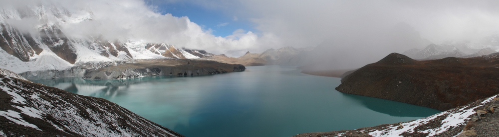
Manang
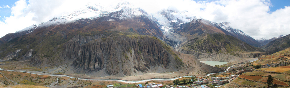
The river flowing between Manang and Gangapurna
Manang (3540 meters, 11614 ft.) is the most popular village to take a rest/acclimatization day, because of its strategical elevation. The village is large, sprawling with tea houses, but lacks the friendliness that exudes from many villages along the trail. Manang will come off as grungy and dirty comparatively. The southern part of town that you will first enter offers newer developments, while heading to the far north will show the local housing and more undeveloped side of Manang.
There are two bakeries (the best one being the first bakery on the right-hand side of the street, as you walk into town), an internet cafe, SWDS, and even a theater in town. When we say theater, we mean a large hut with wooden benches. Where, for only 250 rupees, you can watch “Seven Years in Tibet” with Brad Pitt, complete with a break to hand out small bags of popcorn and warm tea.
Manang is the hub for acclimatization day hikes, anywhere from 30 minute walks to long 8 hour day trails. In town, there is a large map that displays all the possible day hikes within the area. More information is also available at the ACAP office.
A short hike to Gangapurna Lake, which early in the season is commonly still partially frozen, blending beautifully into the snowy foothill. There is also a short hike to the stupa that offers an aerial view of Manang, and can be continued higher for those in need of a true stretch of the legs and lungs.
Manang to Yak Kharka versus Tilicho Base Camp (alternative trail)
From Manang, you can continue on the trail to Yak Kharka. Or you can take an alternate trail to Tilicho Lake — the highest lake in the world, lodging at Tilicho Base Camp. This alternative trek will add 1 – 2 days to your trek. However, it is not necessary to return to Manang, as you can go from Tilicho Base Camp to Yak Kharka, via a route split near Siri Kharka.
We highly recommend the trek to Tilicho Base Camp. Without a doubt it was one of the highlights along the Annapurna Circuit. The route includes a difficult climb and tricky footing within certain areas, and is also prone to landslides. Before leaving Manang check that the bridges along the route are set and the lodges at Tilicho Base Camp are operating, since they run seasonally.
Manang to Tilicho Base Camp
Manang to Khangsar: 1 hr. 35 min.
Continue out of Manang, past the stupa in the center of town. Take a left at the sign to Throng La (approx. 5 minutes past the stupa). Do not take the right hand turn at the second sign to Throng La. Instead, continue straight, making your way out of town. Turn right at the dirt road (it will be the main road you intersect) and head up stream.
The road will merge with another dirt road. Keep heading upstream. In approximately 30 minutes you will reach a bridge – cross it. You will then have a short but steep climb to the top of a plateau. (Beware that there are two plateaus on the eastern side of the river past Gangapurna Lake. Do not be alarmed that you are walking parallel to a plateau. As long as you do not cross the bridge directly out of Manang that leads to the first plateau, you will properly cross the later bridge and ascend to the second plateau.) At the top of the plateau you will see a small ghost house. Continue down the trail for an hour and 15 minutes, until you reach the village of Khangsar (3734 m, 12250 ft.). Before you reach Khangsar, you will come to a gate. Just pull it open, it is unlocked. The same goes for after exiting Khangsar.
Khangsar to Siri Kharka: 1 hr.
Continue on the main road through Khangsar and past the exit gate. From the gate it is a 40 minute walk to the gomba (monastery). There will be a split, stay right and begin climbing. (The left trail continues downwards to the gomba). In 20 minutes you will reach Siri Kharka (4060 m, 13320 ft.).
5 minutes before Siri Kharka is the split to Yak Kharka. Do not take it, but take note of it. As this is the trail you will be taking to Ledar in a day or two.
Siri Kharka to Tilicho Base Camp: 2 hrs. 30 min.
15 minutes past Siri Kharka you will reach the village of Palnay Khadga, which is currently made up of one lodge.
In 20 more minutes you will come to a suspension bridge. Cross and begin the ascent, most likely you will be greeted at the top by yaks. In another 25 – 30 minutes you will reach the split for the Lower and Upper Trail to Tilicho Base Camp. The Upper Trail is not in use. Do not take it! Take the left fork along the lower trail. The trail will continue downwards at a slight descent. In 10 – 15 minutes you will enter the landslide area. Beware of falling rocks. The trail is thin, with carved stairs descending, only to continue wrapping around the mountain in a flat trail. There are three sets of stairs. The landslide area will take approximately 1 hour to cross.
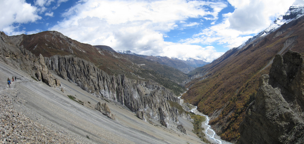
Landslide area on the way to Tilicho Base Camp

Step carefully (still on the way to Tilicho BC)
The trail will continue relatively flat, with a slight descent to Tilicho Base Camp (4150 m, 13616 ft.). There are three lodges in Tilicho Base Camp. Be aware that during high season, bedrooms fill up quickly.
Tilicho Base Camp to Tilicho Lake
Round Trip: 5 – 6 hrs. (Ascent +/- 3 hrs.)
Tilicho Lake, settled at a height of 4990 m, 16371 ft, is considered to be the highest lake on Earth. The day hike to it is not easy, but we think it is well worth it. In order to make sure you have enough time at the top, and to avoid groups and late hours try to start the climb between first light and sunrise. Do not forget to pack snacks and enough water for the day since there is no place to buy or purify water as soon as you start your climb (beside at the lodge next to Tilicho Lake that can sometimes run out of water).
Cross the small bridge over a tributary within Tilicho Base Camp, and turn right before reaching the next lodge. Start your way up by climbing a snake path that will put you on the ridge above the base camp. Keep walking along the ridge wrapping the mountain, pay attention and keep you ears open since landslides are not strangers to this area. The trail moderately ascends until a second snake path, an approximate 2 hours trek from base camp. These series of switchbacks are the steepest part of the ascent and at some parts feel endless. Be sure to breathe, drink water, and take short rests when your body tells you to. When the trail widens and rocks line the edges of the path (it looks like tombstones) you are 20 minutes away from the lake. Continue past a small pool and patches of snow (depending on the season) to the flag marker. The lake lays directly below.
Tilicho Lake
The enchanting view of Tilicho Lake will be discovered after 3 hours of trekking from the Base Camp (depends on your fitness and acclimatization). Upon your arrival, sit on the bench, grab a cup of hot tea and take in the view.
From Tilicho Lake back down to Tilicho Base Camp follow the same route down. Descending it takes between 2hr to 2hr 30min.
Tilicho Base Camp to Yak Kharka
Tilicho Base Camp to Siri Kharka: 2 hrs.
Exit Tilicho Base Camp via the same route that you entered, following the Lower Trail and crossing the landslide area. The trail in this direction will ascend, varying on the degree. However, you will find the staircases easier on the ascent.
Siri Kharka to Yak Kharka: 3 hrs. 20 min.

Split from Siri Kharka to Yak Karka
5 minutes downstream from Siri Kharka is the split to Yak Kharka (4018 m, 13182 ft.). Take a left, ascending the hill. The trail continues with a slight assent and after 45 minutes reaches the old village of Khangsar.
Walk along the old wall of the village for about 30 minutes, till you reach the hilltop, which offers an aerial view of the valley below. Follow the trail, descending to the left. In 45 minutes you reach a seasonal suspension bridge. Cross the bridge and ascend for 30 minutes until the trail merges with the trail coming from Manang. From there it is a 45 minute walk on a relatively flat path to Yak Kharka’s village entrance.
Yak Kharka to Phedi
Yak Kharka to Letar: 40 min.
Yak Kharka is a village with two or three lodges, spread out. Just walking from the beginning to end of town takes 20 minutes. There is also an SWDS in the village. After exiting the village, it is another 20 minute to the suspension bridge that brings you to Ledar.
Ledar to Phedi : 1 hr. 45 min. – 2 hrs.
From Ledar continue along the trail until you reach the fork. Take a left, descending towards the bridge (50 minutes). Alternative Trail: The right fork goes to another bridge and will merge with the left trail in 20 – 30 minutes.
From the bridge, you ascend, reaching the first teahouse in 10 – 15 minutes and the second teahouse in another 10 – 15 minutes. It is around this area that the alternative route merges with the original trail. From the second teahouse to Phedi the trail is relatively flat with minor ascents (35 – 45 minutes).
Phedi to Muktinath
Phedi to Base Camp\High Camp: 1 hr. – 1 hr. 30 min.
(Total ascent from Phedi to Throng La Pass: 1000 meters)
Set out at an hour before first light, as the day’s trek is long. Snacks are also a good idea, as it will be many hours before you reach Chahru, which is a seasonal village. Be sure to have a headlamp with you and step carefully. The trail begins right before the guesthouses and heads directly up the mountainside via a snake path. At the top of the snake path, and after almost an half from the climb to the path, you will come to the High Camp (4925m, 16158 ft.). It is an option to stay there for the night in order to split the path climbing to two days, or for people that started the day from Ledar. It might be the last place to grab food and water until the pass, besides one seasonal hut on the further way up.
Base Camp\High Camp to Throng La Pass: 2 hrs. – 3 hrs. 20 min.
The trail continues ascending less steeply, following the contours of the valley and mountain sides. After an hour the trail reaches a hut that sells snacks and warm tea during the season. Keep climbing, until finally, you come to the Throng La Pass (5416m, 17769 ft.). The sign covered in mass amounts of prayer flags and the endless trekkers posing for photos will be hard to miss. You can also buy the most expensive, 320 rps., cup of tea along the trail in a small hut adjacent to the sign.
Throng La Pass to Muktinath: 3 hrs. – 3 hrs. 30 min.
(Total descent from Throng La Pass to Muktinath: 1650 meters)
The descent is rapid and steep. The main issue of time depends on how much pounding your knees can endure. Be aware that the path does split nearing the end. You will come to an edge and cannot continue forward. Instead take the dirt trail marked red or blue towards the right and not the paved road towards the left. An hour before Muktinath (3760 m, 12336 ft.) you will reach the village of Chaharu. It is a seasonal and hidden village at the base of the mountain. When the small teahouse shacks become viewable, you will be less than 15 minutes away. The remaining section for the day has a small decent, but mostly offers a flat walking ground. The view ahead will be beautiful, with a village in the background surrounded by lush oasis.
Muktinath to Marpha
Muktinath to Jomsom: 5 hr. 30 min. (walking)
There are jeeps that travel along this section of the road, or you can opt for the good-old walking. Be aware that most of this section will follow the paved road and offer views less stellar than the previous days. The jeep ride is 1 hour and 30 minutes, while the trek by foot takes about 5 hours and 30 minutes.
Jomsom to Marpha: 3 hrs.
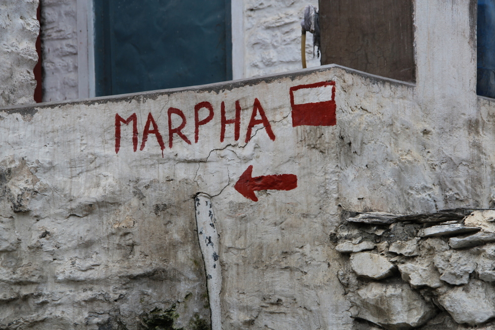
Follow the signs
Taking the Main Street through Jomsom, turn left across from a bridge — following the trail marks. In 30 minutes or less you will reach Thini. A small village with beautiful houses set along the water system that gurgles down the street and is surrounded by orchards and fields.
Up the hill stand the ruins of Gharab Dzong, built by the local King Thing Migchen; the regions original settlement. You can visit Katsapterenga Gomba, named after the five clay statues (5 Treasures) brought from Samye, Tibet. On a clear day, this Gomba offers a breathtaking view of the valley below and peaks beyond.
Head down the mountain on the southern side. The road will split. Do not take the path to the left towards Chairo!!! Instead, continue following the contour of the mountain, wrapping around it. You will then come to a bridge, cross it, and continue left/south to Marpha (2670 m, 8760 ft.).
Alternative trail option: From Jomsom, continue along the car road to Marpha. This road can be unpleasant due to dust and vehicle traffic, but is the most direct path and takes only 1 hour and 30 minutes to 2 hours.
Marpha to Tatopani
Marpha to Tatopani: 12 hrs. – 12 hrs. and 45 min. (walking)
Once again, you have the option to continue by foot or take a bus, a 5 to 6 hour ride.
If you are continuing on by foot this section can be split into a two day trek. The common route is to walk along the car road, though sections of alternative routes exist. The trail continues to decend into Tatopani.
Along the car road, the walking times break up as follow: Marpha to Larjung: 3 hours and 30 minutes, Larjung to Lete: 2 hours, Lete to Ghasa: 2 hours, Ghasa to Pairathaplo: 45 minutes, Pairathaplo to Ruspe Chhahara: 1 hour and 15 minutes, Ruspe Chhahara to Dana: 45 minutes, Dana to Tatopani: 1 hour and 45 minutes.
In Tatopani (1190 m, 3904 ft.), be sure to check out the local hot springs. They have been converted into modern style pools and offer a shower spigot. This village’s name is derived from the Nepali word for hot, “tato.”
Tatopani to Gho Repani
TIMS checkpoint, Tatopani to Sikha: 3 hrs.
After checking in at the TIMS checkpoint in Tatopani, continue along the road. In 20 minutes you will come to the first suspension bridge. Cross the bridge, 5 minutes later crossing another suspension bridge. Then turn left and begin climbing to Sikha (2hrs. 30 min.). Go through the village of Ghara, and on to Sikha (1935 m, 6348 ft.).
Sikha to Gho Repani village: 3 hrs.
The path will continue ascending and is well marked with either trail marks and/or signs. Just keep your eyes open! From Sikha it is a 15 minute walk to the ACAP station. Continue on to Chitre (2390 m, 7841 ft.), a sprawling village. From the ACAP station to the last teahouse in Chitre is 1 hour and 45 minutes.
Continue climbing to the gate of Gho Repani in another 50 minutes. The village of Gho Repani is only 10 minutes after that (2860 m, 9383 ft.).
Side trail: Poon Hill (3193 m, 10475 ft.), leave Gho Repani slightly before first light, as this viewpoint is best at sunrise. The trail starts near the end of Gho Repani village, and is the wide, dirt, path leading up the mountain towards the right (assuming you are heading “south” out of Gho Repani). The ascent takes around an hour, while the descent is 30 to 45 minutes. Personally, we recommend a breakfast of chipati and nak (female yak) cheese, paired with some hot coffee while you take in the view.
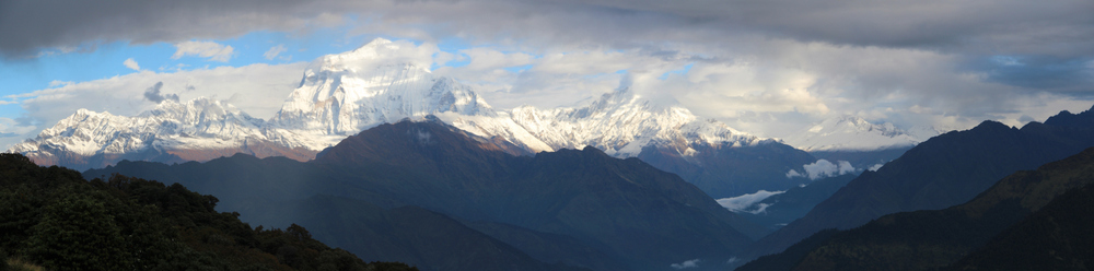
The view from Poon Hill
Gho Repani to Naya Pul
Gho Repani to Ulleri: 3 hrs.
The trail will descend through the green jungle, taking you past beautiful waterfalls and streams. You will come to Nangethanti within 40 minutes. In another 1 hour and 30 minutes you will reach the endlessly sprawling village of Banthanti (2210 m, 7250 ft.), that has random teahouses continuing along the trail.
From Banthanti the series of staircases being. Continue your descent to Ulleri (1960 m, 6430 ft.), which will be 1 hour and 10 minutes past Banthanti.
Ulleri to Naya Pul: 4 hrs.
1 hour past Ulleri will be Tikhedhung. In Tikhedhung you come to the first suspension bridge. Cross and then climb more stairs to the second suspension bridge. After crossing the bridges, continue down a few more sets of stairs. Then make your way through small villages, staying along the main road.
From Tikhedhung to Ramgai is 1 hour, though the sprawling village takes another 30 minutes to walk through.
It is another 1 hour from Ramgai to Birethanti (1025 m, 3362 ft.). Along the main road, after Ramgai, you will see a small sign with an arrow towards Birethanti. Do not follow the sign, but remain on the main trail until you come to the village entrance of Birethanti. (You can take the trail but it is longer and just reconnects to the more direct path later on.)

The last ACAP/TIMS checkpoint along the Annapurna Circuit
Near the end of the village will be your final ACAP checkpoint along the Annapurna Curcuit! After Birethanti, you cross a large bridge toward Naya Pul (1070 m, 3510 ft.), which you will reach in 30 more minutes.
From Birethanti onwards you are walking along the car road. Your two options are to take a taxi from Birethanti or to continue on by foot to Naya Pul (30 minutes walk) to catch a taxi or bus.
Just as a point of reference, a taxi from Birethanti or Naya Pul to Pokhara should cost 1800 to 2000 rps.

Annapurna Circuit Elevations
Mapping your Route
